Beautiful Karamursel
Beautiful Karamursel
Israel 2014 Day 6 of trip Monday June 16, 2014
Israel 2014 Day 6 of trip Monday June 16, 2014
Today we are on our way to Masada fortress. It will be our first stop because we want to get as many sites as possible before it gets too hot.

As soon as we go east from Jerusalem, we begin traveling through the Judean Desert. We will drive east, close to Jericho, and then turn South driving along the Dead Sea. which will be to our left. The Judean Desert is not a desert of sand but a desert of rocks. The sheep work hard for their meals here because vegetation is very sparse. Just about any field of vegetation you see while driving through is from drip irrigation. They can make the desert green, but they presently use lots of pipe to do it with. There are oasis scattered here and there.


Another filling station along the highway.


More vegetation and palm trees.

Notice the camel waiting patiently for the tourists to come by this station.


Israel will not run out of rocks!


We are passing by the Dead Sea. Jericho is near the top, and Masada is near the bottom, about 31 miles long and 9 miles wide. There is nothing moving in this lake because it is dead! It was given an appropriate name.

Our first glimpse of Masada driving down the Highway.

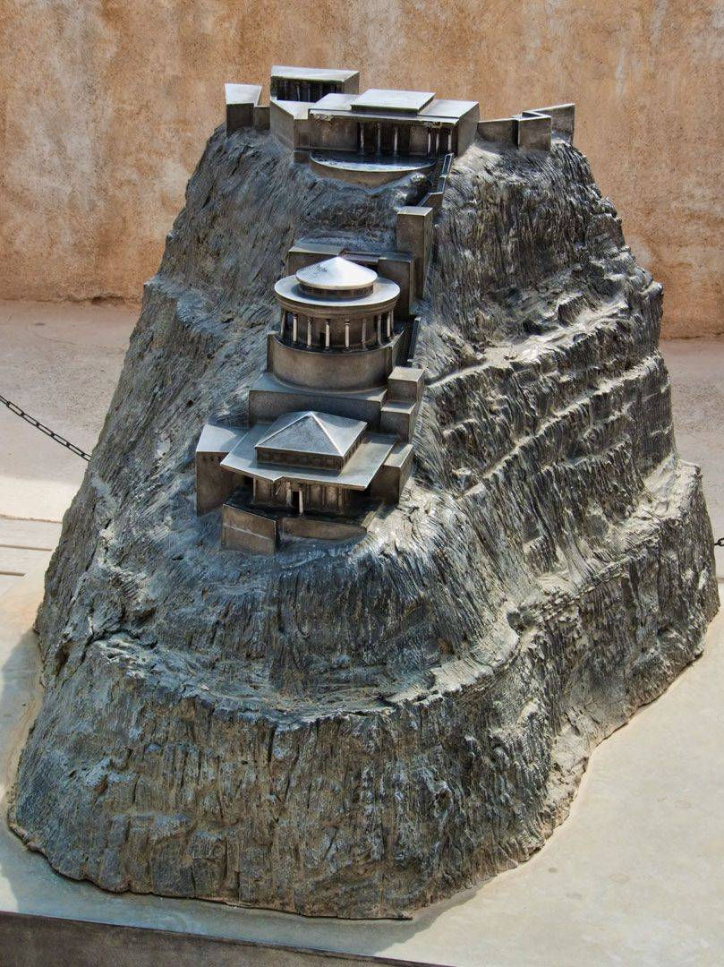
This is Masada. On the right or north face in the picture below, you can see three stair steps at the top. These were the location for Herod's living quarters and palace.

The cliffs on the east edge of Masada are about 1,300 feet (400 m) high and the cliffs on the west are about 300 feet (91 m) high. The natural approaches to the cliff top are very difficult. The top of the plateau is flat and rhomboid shaped, about 1,800 feet (550 m) by 900 feet (270 m). There was a wall around the top of the plateau totaling 4,300 feet (1.3 km) long and 12 feet (3.7 m) high. It had many towers, and the fortress included storehouses, barracks, an armory, the palace, and cisterns that were refilled by rainwater. Three narrow, winding paths led from below up to fortified gates.


Masada is the name given to the ancient mountain-top fortress that has become a symbol of Israeli pride and national struggle. It was here where 1000 Jews - men, women and children - made a defiant stand for 2 years against the Roman legion of 15,000 troups that had conquered the land of Israel. Rather than accept defeat and loss of freedom, nearly all committed suicide. Only seven women and children, who had hidden in part of cistern, chose to survive and surrender. The first costruction and fortification began during the times of the first Jewish Temple (900 BC), and the last was done by Herod the Great at the time of the birth of Christ.


Olga is waiting patiently for us to get to her location so she can begin the History.
(The following comes from Wikipedia.) - Almost all historical information about Masada comes from the 1st-century Jewish Roman historian Josephus. The site was first fortified by Alexander Jannaeus in the first century BC. Herod the Great captured it in the power-struggle that followed the death of his father Antipater. It survived the siege of the last Hasmonean king Antigonus II Matathias, who ruled with Parthian support. In 66 CE, a group of Jewish rebels, overcame the Roman garrison of Masada with the aid of a ruse. After the destruction of the Second Jewish Temple in 70 CE, additional members of the Sicarii rebels fled Jerusalem and settled on the mountaintop. According to Josephus, the Sicarii were an extremist Jewish splinter group antagonistic to a larger grouping of Jews referred to as the Zealots, who carried the main burden of the rebellion. Josephus said that the Sicarii raided nearby Jewish villages including En Gedi, where they massacred 700 women and children.
In 73 CE, the Roman governor of Iudaea Lucius Flavius Silva headed the Roman legion X Fretensis and laid siege to Masada. The Roman legion surrounded Masada, and built a forticfication wall and then a siege ramp against the western face of the plateau.
According to Dan Gill, geological investigations in the early 1990s confirmed earlier observations that the 375-foot (114 m) high assault ramp consisted mostly of a natural spur of bedrock. The ramp was complete in the spring of 73, after probably two to three months of siege, allowing the Romans to finally breach the wall of the fortress with a battering ram on April 16. Romans took the X Legion and a number of auxiliary units and Jewish prisoners of war, totaling some 15,000 troops in order to crush Jewish resistance at Masada. A giant siege tower with a battering ram was constructed and moved laboriously up the completed ramp. Originally, Jewish rebels on top of Masada threw stones at those building and constructing the ramp. When this plan was realized, the Romans put captured Jewish prisoners from previously conquered towns to work the ramp. The Jewish people on top of Masada stopped killing those who built the ramp, choosing not to kill their fellow Jews, even though they understood this might result in the Romans penetrating the fortress. The walls of the fortress were breached in 73 CE. According to Josephus, when Roman troops entered the fortress, they discovered that its 960 inhabitants had set all the buildings but the food storerooms ablaze and committed mass suicide or killed each other. Josephus wrote of two stirring speeches that the Sicari leader had made to convince his fellows to kill themselves. Only two women and five children were found alive. Josephus presumably based his narration upon the field commentaries of the Roman commanders that were accessible to him. There are significant discrepancies between archaeological findings, and Josephus' writings. Josephus mentions only one of the two palaces that have been excavated, refers only to one fire, while many buildings show fire damage, and claims that 960 people were killed, while the remains of only 28 bodies have been found.
The year of the siege of Masada may have been 73 or 74 CE.

There was a movie made with Peter O'Toole about this.
Herod's palaces 2000 years ago.

Today

Notice the Romans constructed the ramp on the west side which was much nearer the top of the plateau. The Dead Sea would be located just out of the top left of the picture.

A replica of an ancient siege machine that they pulled up the slope of the earthen ramp. This was located at the bottom of the ramp on the western side of Masada.

Walking North to where most of the buildings stood.

It was hot! I'm glad we were here early in the morning!


Looking down at the parking lot and the national park buildings.

The cable car landing at the top of Masada.


The dark structure in the left middle of the picture is an open amphitheater where concerts, plays, and other activities are held.

Looking North from Masada.


The outlines are of where the Roman camps were.

The walkways to the lower palaces.


Another interesting feature is the canals dug along the face of the mountain. When it rained the rain would collect in the canals and then flow down into one of the reservoirs inside the mountain.

Pigeons were kept here.

It was hot walking around up here and we were all drinking often from our water bottles.


Getting ready to go back down.

Hot digs a McDonald's inside!

A welcome visitor, an Ibex. An Ibex is also their mascot for their national park signs.

Below we have returned North in the bus to Ein Gedi where we walked up a path to a waterfall. Just beautiful.

The Ein Gedi nature reserve was declared in 1971 and is one of the most important reserves in Israel. The Ein Gedi nature reserve includes two spring-fed streams with flowing water year-round. There are many different animals in this area.

The Bible records that 3000 years ago, David hid from King Saul at Ein Gedi. When David surprised the King and spared his life after finding him unarmed, Saul said David would succeed him on the throne.

These are caves in the Ein Gedi cliffs. Located on the Dead Sea's western shore, Ein Gedi ("spring of the goat") is a desert oasis with waterfalls, pools, of water and two large streams. It is a hiker's paradise with beautiful foliage, exotic birds and a range of wildlife, including rabbits, deer, ibex and leopards.

After a brief ride in the bus heading north, we have arrived at the Qumran Caves where the Dead Sea Scrolls were found in 1947 by a shepherd boy. We ate lunch and shopped here before heading to look at the caves in the cliffs.


Notice the caves in the cliffs.

This is one of the caves where the scrolls were found. These shepherd boys were climbers. Manuscripts have been discovered in around 12 caves. It is not known precisely who wrote those sectarian scrolls, but we can say that the authors seemed to be connected to the priesthood, were led by priests, disapproved of by the Jerusalem priesthood, encouraged a strict and pious way of life, and expected an imminent confrontation between the forces of good and evil.

The scrolls and fragments found are the oldest surviving copies of the Old Testament Books and other writings of a coming messiah.

Olga always took good care of us and informed us of what was going on.

We are in the bus again heading north along the Dead Sea.

We are getting off the bus and getting ready to go swimming in the Dead Sea.

This place was hot! After the other warnings about what the high salt could do, we decided just to watch the brave souls go in.The only thing alive in the Dead Sea are the brave tourists!

Small sections of the northernmost portion of the Lower Jordan, between the Sea of Galilee and the confluence with the Yarmouk River, have been kept pristine for baptisms. Most polluted is the 100 kilometre downstream stretch.

Much of the water is being pulled out for different purposes before it gets to the Dead Sea. As a result it is getting smaller and if something is not done it will be dried up within 100 years.

One casualty from Masada!


The beautiful mosque with the blue domes in Jericho.


Jericho is believed to be one of the oldest cites in the world. It was also the first city captured by the Israelites upon entering the land of Canaan following their 40 years of wandering in the desert after the exodus from Egypt. Before the outbreak of the Palestinian War in 2000, the Palestinian Authority had been developing the town in hopes of making it a major tourist attraction, most notably erecting a large casino and hotel at the outskirts of the city.

Jericho sits between Mt. Nebo in the east, the Central Mountains to the west, and the Dead Sea to the south.


The Bible tells us that Jesus met a tax collector "Zacchaeus" in a sycamore tree here in Jericho.

Taking a picture of the tree and the salesmen ready to help you buy something.

Older part of Jericho.


Camel riders


The camel looks calm and cool!


Wadi Qelt is a valley, wadi, or stream running west to east across the Judean Desert in the West Bank. Originating near Jerusalem, it terminates near Jericho, near the Dead Sea.


